Trail Walking Le Lorrain - Boucle Morne Capot via La Pirogue - Photo

Boucle Morne Capot via La Pirogue

 Lamartiniere
Lamartiniere

User GUIDE

© OpenStreetMap contributors
Length
Length
10.3 km
Max alt
Max alt
282 m
Uphill gradient
Uphill gradient
307 m
Km-Effort
Km-Effort  
14.4 km
Min alt
Min alt
106 m
Downhill gradient
Downhill gradient
306 m
Boucle
Boucle
Yes
Creation date :
2024-08-07 10:57:54.099
Updated on :
2024-08-19 22:15:17.356

(0 Reviews)

Walking
Walking
3h30
Difficulty : Medium

Scan this QR Code to open this trail in the SityTrail application

FREE GPS app for hiking

Logo SityTrail SityTrail

IGN / Geographical institutes

Download SityTrail from the App Store Download SityTrail from Google Play

Logo SityTrail SityTrail World

The world is yours!

Download SityTrail from the App Store Download SityTrail from Google Play Download SityTrail on Huawei AppGallery

About

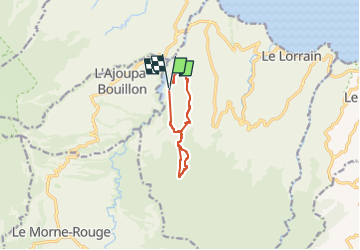
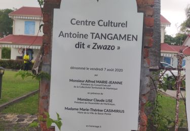
Trail Walking of 10.3 km to be discovered at Martinique, Unknown, Le Lorrain. This trail is proposed by Lamartiniere.

Description

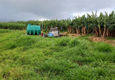
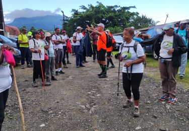
Randonnée de 10 km  avec autorisations de passages sur plantations et parcelles de terrains.

Elevation profile

Photos

Positioning

Country:
France
Region :
Martinique
Department/Province :
Unknown
Municipality :
Le Lorrain
Location:
Unknown
Start:(UTM)
704723 ; 1639445 (20P) N.

Trails nearby

Trail Walking Le Morne-Rouge - Mac Intoch - Morne Capot - Photo
Walking
GUIDE
Lamartiniere

Walking

Medium
(1)
Le Morne-Rouge, Martinique, Unknown, France
9.4 km | 14.9 km-effort
4h 53min
No
Trail sport Le Morne-Rouge - Boule cap 21 domaine de la vallée  - Photo
sport
GUIDE
manuelPerez

sport

Very easy
Le Morne-Rouge, Martinique, Unknown, France
9 km | 13.7 km-effort
Unknown
Yes
Trail Walking Le Lorrain - La Crabière-Tapis Vert - Photo
Walking
GUIDE
Jean-Luc Farant

Walking

Medium
Le Lorrain, Martinique, Unknown, France
7.9 km | 10.3 km-effort
2h 20min
No
Trail Walking Basse-Pointe - Exploitations agricoles en boucle N°1 - Photo
Walking
GUIDE
Lamartiniere

Walking

Medium
Basse-Pointe, Martinique, Unknown, France
13.2 km | 16.5 km-effort
4h 0min
Yes
Trail Walking Le Lorrain - Fond capot oceanic fond cani morne Degras - Photo
Walking
GUIDE
manuelPerez

Walking

Le Lorrain, Martinique, Unknown, France
8.5 km | 11.9 km-effort
3h 44min
Yes
Trail Walking Le Lorrain - Mornes Capot / Lorrain Martinique - Photo
Walking
GUIDE
GabyG

Walking

Medium
(1)
Le Lorrain, Martinique, Unknown, France
8.5 km | 11.8 km-effort
3h 41min
Yes
Trail Walking Basse-Pointe - Boucle de chalvet, Pécoule vers Chalvet. - Photo
Walking
GUIDE
GabyG

Walking

Medium
Basse-Pointe, Martinique, Unknown, France
6.5 km | 7.8 km-effort
3h 2min
Yes
Trail Walking L'Ajoupa-Bouillon - Défi 2022 étoile - Photo
Walking
GUIDE
manuelPerez

Walking

L'Ajoupa-Bouillon, Martinique, Unknown, France
9.1 km | 15.6 km-effort
3h 33min
No
Trail Walking Basse-Pointe - Grande Boucle sur Basse pointe. - Photo
Walking
GUIDE
GabyG

Walking

Very difficult
Basse-Pointe, Martinique, Unknown, France
14.1 km | 17.6 km-effort
4h 55min
Yes


Close
My subscriptions